Adina Sommers has several rare and special antique maps in her collection. Our blog will provide a weekly review of our rare and antique maps with information on the printers as well as persons who influenced the map design. This blog provides information on Johann Schott’s, Tabula Septima Asiae-Ptolemey (1513) and Henri Abraham Chatelain’s, Carte tres curieuse de la Mer du sud (1719).
Johann Schott’s, Tabula Septima Asiae-Ptolemey
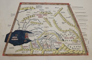
Ptolemey – Johann Schott, Tabula Septima Asiae, ca. 1513
The 1513 edition of Ptolemy’s Geographica depicts the classical view of Central Asia and Turkistan, with a horizontal delineation of the Caspian Sea. Johann Schott, Tabula Septima Asiaeappeared in this edition. The map is an original hand colored woodcut trapezoid map with a watermark of a grape. The map shows the Caspian Sea, Russia and Turkmenistan, Kasachstan, Usbekistan and Hindukuschwith
Special Features: Original hand colored woodcut.Trapeziod map shows the Caspian sea, Russia and Turkmenistan, Kasachstan, Usbekistan and Hindukusch. Water mark of a grape
Dimensions: 28 x 46 cm
Interesting Facts about Claudius Ptolemaeus
Ptolemy (Claudius Ptolemaeus) Geographica compiled and summarized geographic information accumulated by the Greeks and Romans up to that time. His work showed locations by longitude and latitude, representing a spherical earth on a flat surface, and developing the first equal area map projection. Geographica included a world map, 26 regional maps, and 67 maps of smaller areas. Ptolemy also standardised the orientation of maps, with North at the top and East on the left, thereby placing the known world in the upper left, a standard that remains to this day. Ptolemy collected, analysed, and presented geographical knowledge so that it could be preserved and perfected by future generations
Chatelain, H.A., Carte tres curieuse de la Mer du su
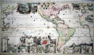
Chatelain, H.A., Carte tres curieuse de la Mer du sud
Henri Abraham Chatelain (1684 – 1743), and his father Zacharie Chatelain (d.1723) and Zacharie Chatelain Junior (1690-1754) published seven volumes of the Atlas Historique, Ou Nouvelle Introduction à L’Histoire between 1705 and 1720, with a second edition appearing in 1732. Carte Tres Curieuse De La Mer Du Sud is one of the most outstanding maps from the Atlas Historique. This impressive map focuses on North and South America while simultaneously incorporating the Pacific and Atlantic Oceans. An important detail of the map is the depiction of California as an island – a somewhat outdated concept at the time of publication and a contrast to the geographically accurate (relatively) delineation of the Great Lakes and the Mississippi
Special Features: Original hand colored copper print. Amsterdam ca. 1720. Map shows total America with California as an island, partly south east Asia and west Africa, with many figurative representations and inset maps of islands, city maps and bays. Beautiful and splendid map printed on 4 plates and joined together.
Dimensions: 81 x 140,5 cm.
Interesting Facts about Henri Abraham Chatelain
Henri Abraham Chatelain was a skilled artist who combined his wealth of historical and geographical information with delicate engraving and an uncomplicated composition. His work included studies of geography, history, ethnology, heraldry, and cosmography. His maps with his elegant engraving are a superb example from the golden age of French mapmaking.
These maps and many more rare and special maps can be found on our website-asommer.de.


